Mission
Understanding how convective clouds develop and impact the Earth’s radiation budget remains a key challenge in atmospheric science. While high-resolution models can now simulate cloud systems at meter-scale resolution, observations to evaluate their representation of cloud formation, growth, entrainment, and radiative effects remain limited. The forthcoming C3IEL and EarthCARE missions will provide complementary perspectives on these processes, offering a unique opportunity to connect the external morphology of convective clouds with their internal microphysical and dynamical structure.
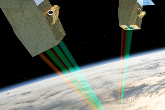
The CNES-ISA C3IEL mission, scheduled for launch in 2028, will fly in a near-13:30 local-time descending orbit with two nanosatellites observing convective clouds stereoscopically in the visible and near-infrared. Its 17 m-resolution radiometers will retrieve 3D cloud-top morphology and vertical development velocity, characterizing the outer geometry and dynamical evolution of convective systems. The ESA-JAXA EarthCARE mission, launched in 2024, operates in a near-14:00 local-time descending orbit with a synergistic set of active and passive sensors (ATLID lidar, CPR radar, MSI imager, BBR radiometer) providing vertical profiles of hydrometeor properties, vertical motion, and radiative flux divergence. With their close local times and similar geometry, C3IEL and EarthCARE will both sample the same afternoon and nighttime convective regimes, enabling near-coincident or sequential observations of evolving systems. ESA's extension of EarthCARE's lifetime from three to ten years makes temporal overlap with C3IEL a unique opportunity for cross-validation and cloud-process studies.
This PhD project will determine how C3IEL and EarthCARE can be jointly exploited to characterize convective cloud processes and support the scientific preparation of C3IEL. It will use numerical and statistical methods to combine and extend their respective information content, preparing for joint interpretation once both datasets are available. High-resolution cloud structures from Meso-NH simulations, already available to the proposing team through C3IEL preparatory work, will serve as a common reference to generate synthetic C3IEL and EarthCARE observations using their respective simulators, both based on the 3DMCPOL Monte Carlo radiative-transfer code. These simulators will be merged into a unified framework capable of reproducing both active (radar-lidar) and passive (multi-angle imager) measurements for consistent multi-sensor analyses. Research-level algorithms for retrieving macro- and microphysical cloud properties from both missions, including the varpy/DARDAR algorithm adapted to EarthCARE, are being actively developed by the team, enabling the construction of complete joint end-to-end simulators. By analyzing the sensitivity of each instrument to key dynamical and microphysical parameters through ensembles with varying microphysical assumptions, we will identify complementary observables linking cloud-top geometry and motion (C3IEL) to internal vertical structure and hydrometeor properties (EarthCARE). This will establish a physically consistent framework for interpreting future C3IEL and EarthCARE measurements and quantifying their information content using Jacobian-based and machine-learning approaches. These methods may also extend the retrieval capabilities of each mission beyond their individual sensitivities, for example inferring hydrometeor profiles from C3IEL or better constraining 3D structure from EarthCARE.
A major technical outcome will be the consolidation of a unified lidar-radar-C3IEL simulation framework applicable to a wide range of observing systems. This development will form the backbone for exploring synergies between C3IEL and EarthCARE and may later extend to future lidar or radar missions such as NASA's INCUS constellation, or to the combined use of C3IEL and ground-based radar networks. These developments will also directly support C3IEL calibration and validation activities, providing synthetic datasets and tools for designing and optimizing multi-sensor field-campaign strategies involving lidar and radar instrumentation.
The project will deliver both scientific and strategic benefits for CNES and the wider EarthCARE-C3IEL community by strengthening readiness for joint data exploitation and supporting mission validation and synergy efforts, while building on the experience from the CALIPSO mission. By linking high-resolution modeling with synthetic and satellite observations from both missions, it will enhance the interpretation of retrieved cloud properties, guide the design of validation and field campaigns, and provide a reference framework for cross-mission analyses. The project will also build on, and contribute to, collaborative frameworks such as the ongoing CNES APR projects C3IEL, EarthCARE2025, and VARALI.
=================
For more Information about the topics and the co-financial partner (found by the lab!); contact Directeur de thèse - odran.sourdeval@univ-lille.fr
Then, prepare a resume, a recent transcript and a reference letter from your M2 supervisor/ engineering school director and you will be ready to apply online before March 13th, 2026 Midnight Paris time!
Profile
Laboratoire
Message from PhD team
More details on CNES website : https://cnes.fr/fr/theses-post-doctorats